NOW ACCEPTING BITCOIN
Add to cart and proceed to checkout to pay with Bitcoin and get 25% OFF.
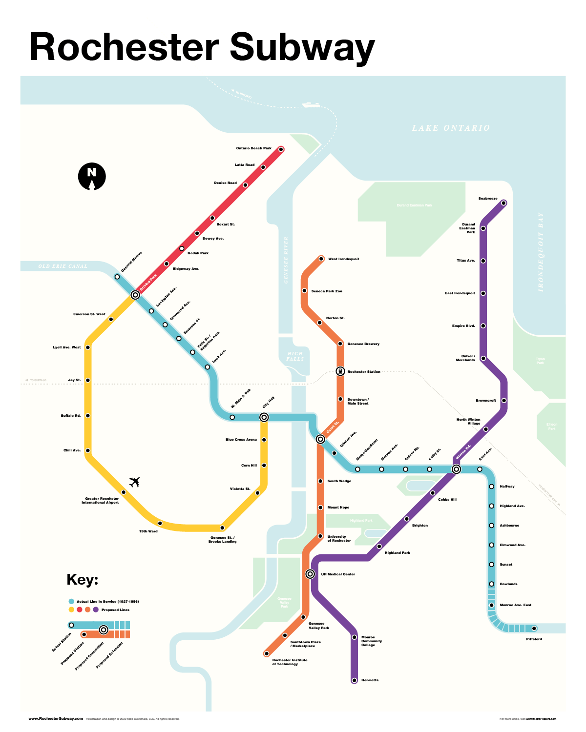


Rochester Subway Map
$30.00
Don’t try to make sense of it – this is a just-for-fun, ridiculously insane, completely nonsensical, subway map for Rochester (except for the blue line… that part was real)
- 16″x20″ Poster (Matte Print)
- FREE Shipping (U.S.)
- See full description below
454 in stock (can be backordered)
About the Rochester Subway Map
The “Fantasy Subway” That really was. Sort of.
Most people have no idea that Rochester, NY ever had a subway. But from 1927 until 1956, red and cream colored trolley cars and four-car commuter trains rushed through tunnels beneath downtown Rochester — and above ground from the General Motors plant all the way to Elmwood Avenue and Rowlands.
Built within the old Erie Canal bed and formally named the Rochester Industrial and Rapid Transit Railway, it was known to most as simply the “Subway” and was built to ease interurban traffic from the streets of Rochester. It also served as an interchange for the five railroads that entered the city and as a link to interurban lines serving the east and west.
For more about the history of the real Rochester Subway, visit RochesterSubway.com.
There were several proposals in its final years that would have significantly expanded the line from downtown to Pittsford, Charlotte Beach, and the airport. The Subway was never really meant to die. This map shows how the system might have looked today – had it survived. The actual path of the Rochester Subway (and old Erie Canal) is depicted in blue.
Popular stops on this modern day interpretation of the Rochester subway include tourist destinations such as Seabreeze Amusement Park, Seneca Park Zoo, and Highland Park. If you're flying into Rochester for a trade show or event the Yellow line provides a direct rail connection between Greater Rochester International Airport and Blue Cross Arena in downtown Rochester. From there you can hop on the Blue line to Frontier Field and Marina Auto Stadium, or head east across the Genesee River to Rochester Riverside Convention Center. While you’re in the city of Rochester be sure to take in the history and diverse cultural offerings of Corn Hill, South Wedge, East Avenue and Monroe Avenue – or meet up with friends for drinks at the famous Genesee Brewery. Transfer to the Orange line and head south to visit University of Rochester or Rochester Institute of Technology. Jump on the Red line to take care of business at Kodak Park. The subway also provides quick access to:
Rochester Area Shopping
- Downtown Rochester
- Pittsford Plaza
- Monroe Ave.
- Brighton (12 Corners)
- Southtown Plaza
- Marketplace Mall
Rochester Area Colleges
- University of Rochester
- Rochester Institute of Technology
- Monroe Community College
- Brockport Downtown
- Nazareth College (Pittsford)
Rochester Neighborhoods & Suburbs
- Pittsford
- Brockport
- Henrietta
- Irondequoit
- East Ave.
- Mount Hope
- South Wedge
- Corn Hill
- 19th Ward
- Charlotte
- Browncroft
- North Winton Village
And much more!


Reviews
There are no reviews yet.